Charting the Next Decade

Portrait of Jasmine Ruys

PRESIDENT'S MESSAGE

What will College of the Canyons be in 10 years?

That simple question led to months of engaging conversations where hundreds of people evaluated the college as it is today, and more importantly, what it can become in the future.

Employees, students, board members and community leaders gave voice to these discussions and their imagination, insights and shared passion for the success of our college culminated in this Integrated Planning Framework that you are reading: Canyons Compass: Charting the Next Decade of Success at College of the Canyons.

It was a privilege to participate in the process, and listen to the vast array of perspectives shared. Among the diversity of opinions, certain qualities and characteristics were consistently mentioned to describe our college: Supportive. Accessible. Innovative. Welcoming. Agile. Community-driven.

We aspire to uphold all of those values, and they are woven into Canyons Compass. The plan not only casts a vision for the growth of our campuses over the next decade and beyond, but it also serves as a statement of our principles, and how we will act on them.

Above all, this plan stands as a declaration of possibilities. For nearly 60 years, our community has relied on College of the Canyons to turn aspirations into accomplishments. Here, students combine their desire for change with our instruction, resources, and support. The resulting growth unlocks new and rewarding opportunities that enable them to achieve what they envisioned they could become.

In the same way, Canyons Compass captures our vision for the future, one in which College of the Canyons remains a gateway to opportunity by growing and enhancing its capabilities to support and serve our students and the wider community through continued partnership and innovation.

With your help, we will do that over the next decade to ensure that College of the Canyons delivers on the promise of possibility.

With deep appreciation,

Signature of Jasmine Ruys

Dr. Jasmine Ruys
Superintendent/President


Canyons Compass logo with a stylized compass graphic and the tagline “Charting the Next Decade of Success at College of the Canyons.”.
Graduates in blue caps and gowns sit in a row at an outdoor commencement ceremony, smiling and looking toward the stage at sunset.

1 | Planning Process

APPROACH

During the 2025-26 academic year, College of the Canyons partnered with Gensler, a global design firm specializing in inclusive, future-ready campus environments, to develop Canyons Compass: Charting the Next Decade of Success at College of the Canyons, the college's new 10-year Integrated Planning Framework. This partnership reflects the college's commitment to fostering a positive campus climate through an inclusive and strategic planning process that ensures our future direction aligns with shared institutional values and vision. Canyons Compass was developed through a dynamic and collaborative process that was integrated, participatory, and data-informed. A 5-step approach served as a guide for the planning process that began in the summer of 2025 and extended through June 2026.

COLLABORATIVE 5-STEP APPROACH

Five-step process diagram with connected circles labeled 1 Prepare, 2 Engage, 3 Frame, 4 Explore, and 5 Recommend.

Jun-Aug 2025 Aug-Oct 2025 Oct-Jan 2026 Jan-Mar 2026 Mar-Jun 2026


PARTICIPATION

The planning process was designed to maximize participation opportunities from the large and diverse College of the Canyons community. Interactive workshops, open forums, listening sessions, focus groups, and online surveys were intentionally designed to amplify diverse voices from both internal and external communities.

PLANNING TASKFORCE

A Planning Taskforce comprised of campus leaders provided expert insight and strategic direction throughout development to ensure the framework is responsive, actionable, and goal-aligned. The taskforce charge:

  • Provide expert advice to the CEO on the development of the college’s new 10-year Integrated Planning Framework branded as Canyons Compass
  • Guide the development, review and collegewide vetting of Canyons Compass.
  • Analyze and discuss key findings and recommendations
  • Serve as first readers to review and comment on drafts
  • Serve as communication liaison to campus constituent groups

TASKFORCE

Jasmine Ruys
Superintendent/President

Daylene Meuschke
Vice President, Institutional Research, Planning & Institutional Effectiveness

Erin Tague
Vice President, Facilities Planning, Operations & Construction

Eric Harnish
Vice President, Public Information, Advocacy & External Relations

Jeff Gregor
Vice President, Workforce & Economic Advancement

Jason Hinkle
Vice President (Interim), Business Services
Miranda Zamudio
Vice President (Interim), Human Resources

David Vakil
Vice President (Interim), Instruction
Clinton Slaughter
Vice President (Interim), Student Services
Paul Wickline
Associate Vice President, Canyon Country Campus

Lisa Hooper
Academic Senate President
Michael Monsour
Classified Senate President

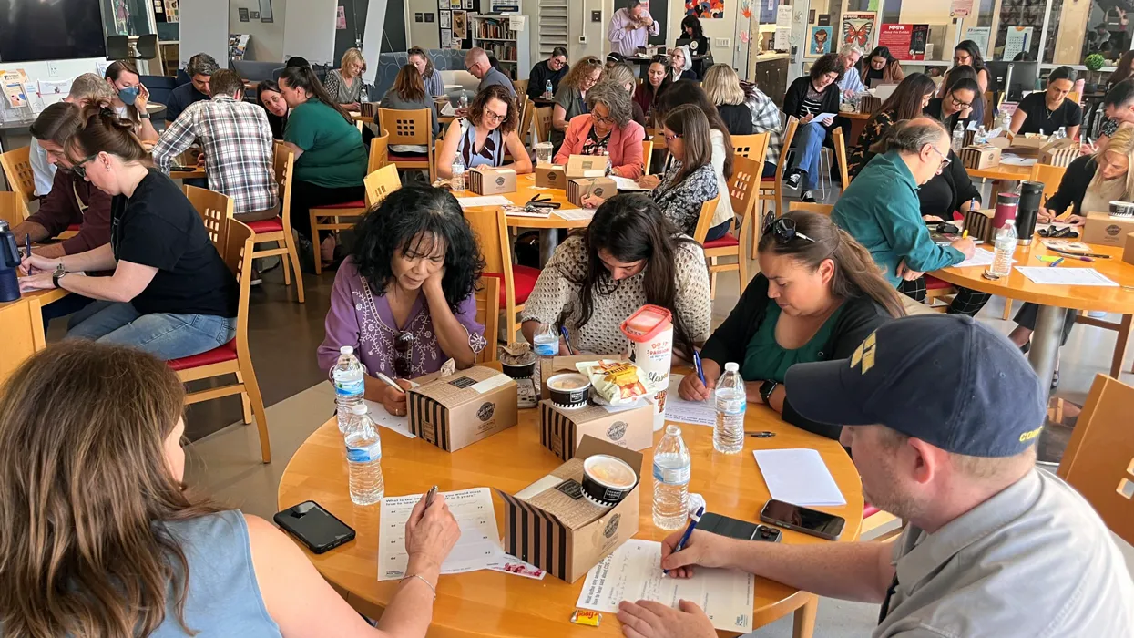
Group of adults seated at round tables in a bright community room, writing on worksheets with lunch boxes and water bottles on the tables.

2 | Engagement
OVERVIEW

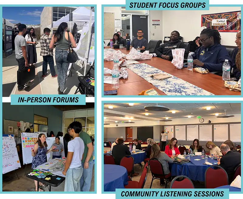
Canyons Compass includes feedback in multiple modalities and from a range of stakeholders. Several campus and community engagement sessions were conducted as part of the Canyons Compass planning process. Engagement activities included a comprehensive Online Survey, in-person Campus Forums and Student Focus Groups held at both the Valencia and Canyon Country campuses, Community Listening Sessions, and presentations to the Board of Trustees.
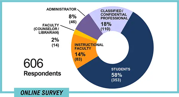
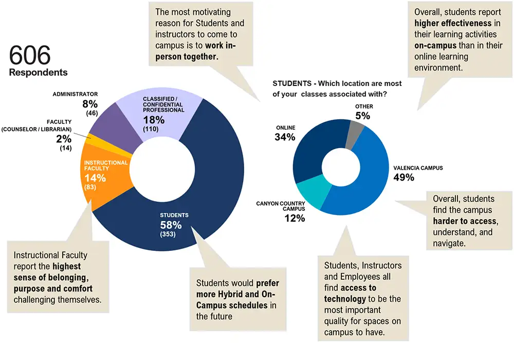
Donut chart of 606 online survey respondents by role: Students 58% (353), Classified/Confidential Professional 18% (110), Instructional Faculty 14% (83), Administrator 8% (46), and Faculty (Counselor/

Collage of community engagement activities showing an outdoor in-person forum, a student focus group meeting around a conference table, and a community listening session with roundtables and wall note

IN-PERSON FORUMS

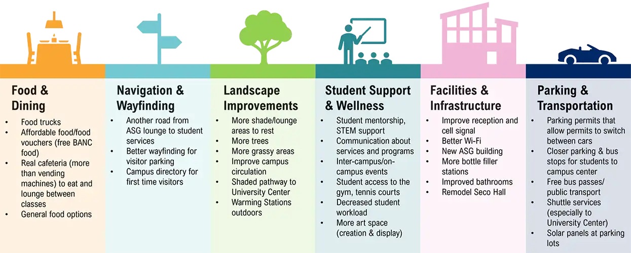
At the start of the planning process, faculty and staff were invited to participate in an Opening Day Open Forum in August 2025. Participants engaged with the planning team through a series of interactive boards and conversations. Information was collected, analyzed, and used to inform facilities planning processes. At the beginning of the academic year, the broader college community was invited to participate in Campus Forums at each campus. Students, faculty, administrators, and classified professionals engaged with the planning team through a series of interactive boards and conversations. Information was collected, analyzed, and used to inform facilities planning processes. Students and faculty were asked to share their ideas of how to improve the College of the Canyons experience. Below is a summary of the six themes that emerged.

Color-coded infographic summarizing campus improvement priorities: Food & Dining, Navigation & Wayfinding, Landscape Improvements, Student Support & Wellness, Facilities & Infrastructure, and Parking/

ONLINE SURVEY

EDUCATION ENGAGEMENT

From Sept. 16 to 28, 2025, College of the Canyons conducted a comprehensive collegewide survey whose purpose was to gather meaningful insights into the experiences, expectations, and overall effectiveness of campus operations from the perspective of its diverse community members.

The survey instrument, designed by Gensler, was used to assess a wide range of topics, including learning experience, teaching experience, working experience, and areas for improvement. The goal of collecting these data was to better understand the needs and perspectives of the college's diverse stakeholders and to inform future planning and decision-making processes.

Infographic summarizing a 606-person campus survey, with donut charts showing respondents are mostly students (58%) and classes are associated mainly with Valencia Campus (49%) or online (34%), plus a

LISTENING SESSION

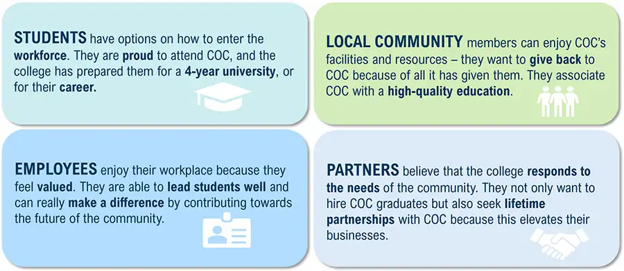
Community members were invited to attend a listening session to share their perceptions of College of the Canyons and their thoughts about what the college should focus on for the next decade. Participants included local business and industry leaders, educational partners, and city representatives.

COC TODAY AND FUTURE

Participants were asked to describe College of the Canyons today and how they would describe an ideal COC. Overall, participants described College of the Canyons currently as a welcoming and supportive environment and hope that the college will grow in its inclusivity and standard of education in the future.

FUTURE CASTING

Four-panel infographic describing how students, local community members, employees, and partners view COC, with small icons for graduation cap, group of people, ID badge, and handshake.

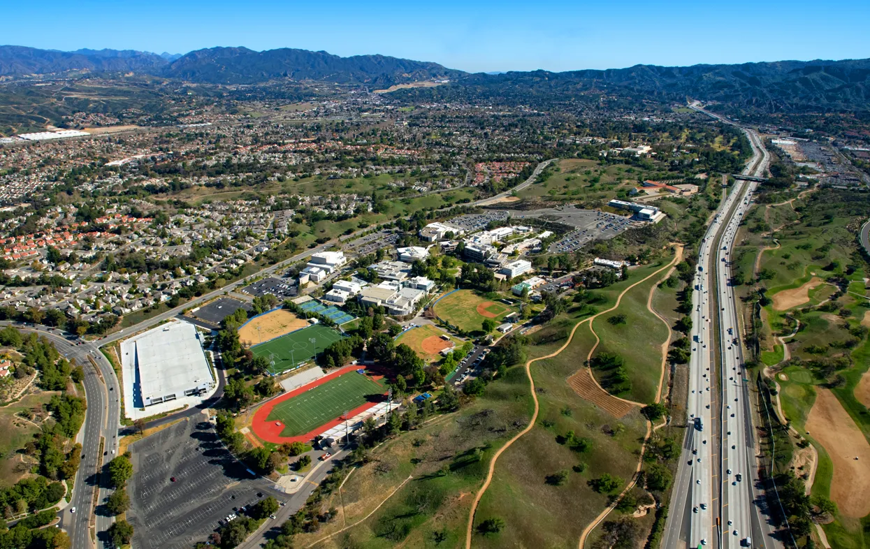
Aerial view of the Valencia campus with sports fields and a running track beside a highway, with hills and mountains in the distance.
3 | Campuses Today

VALENCIA

EXISTING CAMPUS

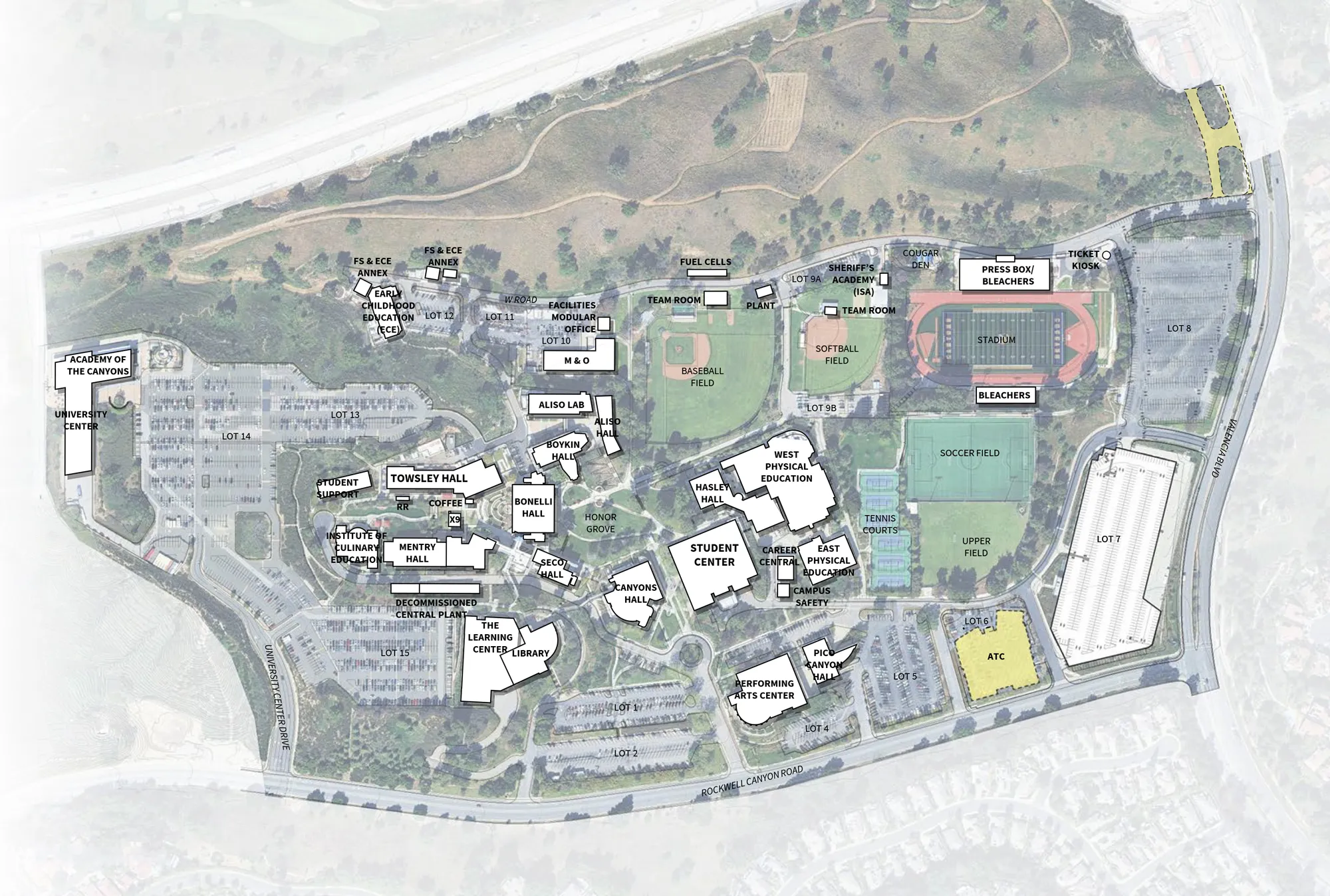
The Valencia campus sits on 153.4 acres of rolling, tree-dotted hills bordered by Rockwell Canyon Road to the east and Valencia Boulevard to the north. The accompanying graphic represents the existing baseline conditions of the campus for the development of this plan. Click map to enlarge.

Legend with two swatches: solid-outlined rectangle labeled “EXISTING” and dashed-outlined yellow rectangle labeled “PROJECTS IN DEVELOPMENT.”

Overhead Valencia campus site map showing labeled buildings, parking lots, and athletic facilities including a stadium, baseball and softball fields, soccer field, and tennis courts.

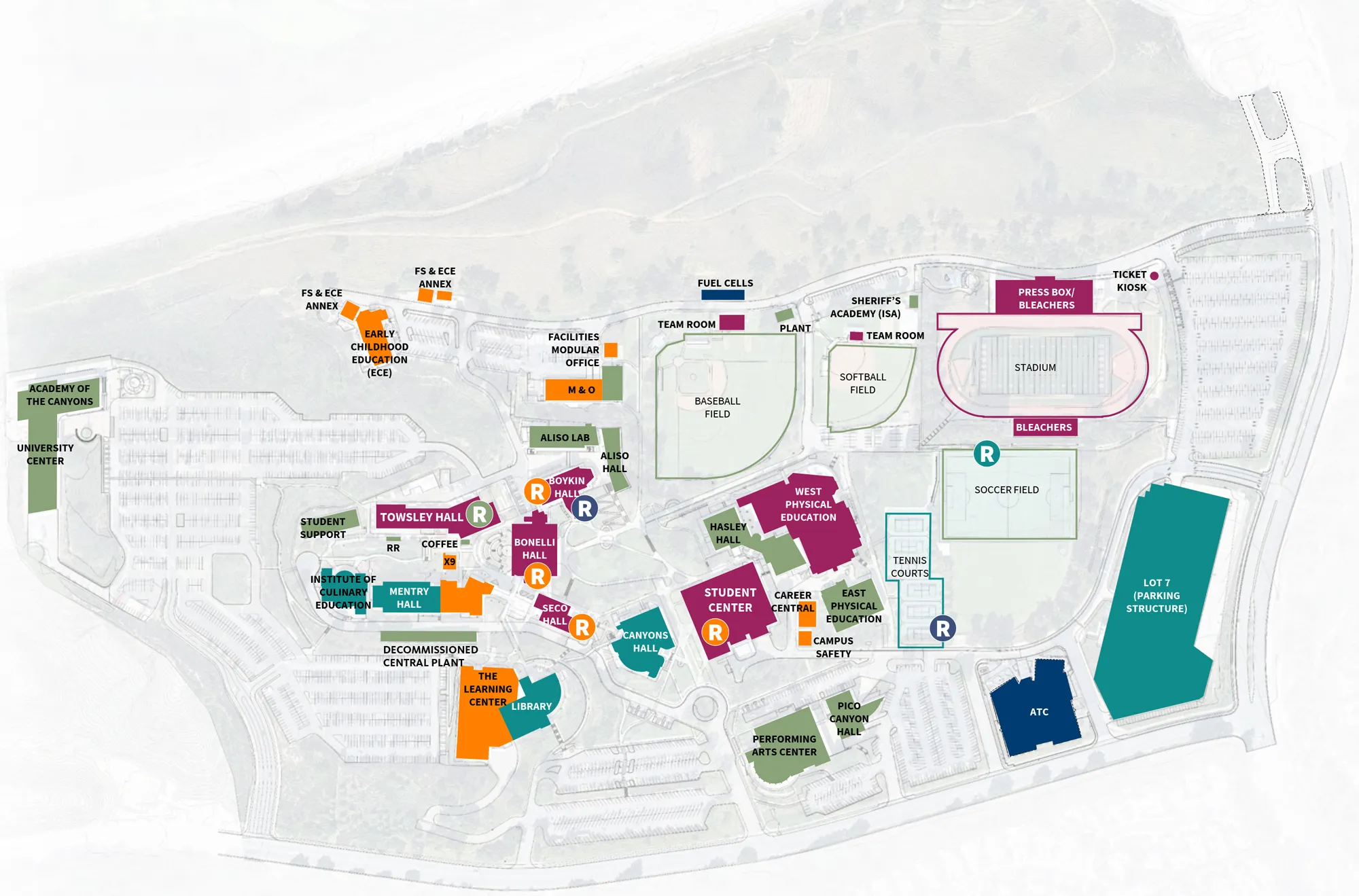
Color-coded Valencia campus map showing building locations and athletic facilities, including a stadium, soccer field, baseball and softball fields, and parking structure Lot 7.This map graphic illustrates the development of the campus with buildings color-coded to indicate the decade of original construction and renovation. While many of the college’s current buildings are from the 1970s, the college has expanded over the decades with a series of new buildings reflecting its growth and progress. Click map to enlarge.

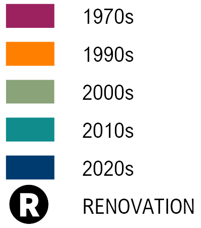
Legend with colored swatches labeled 1970s, 1990s, 2000s, 2010s, and 2020s, plus a circled “R” symbol labeled Renovation.


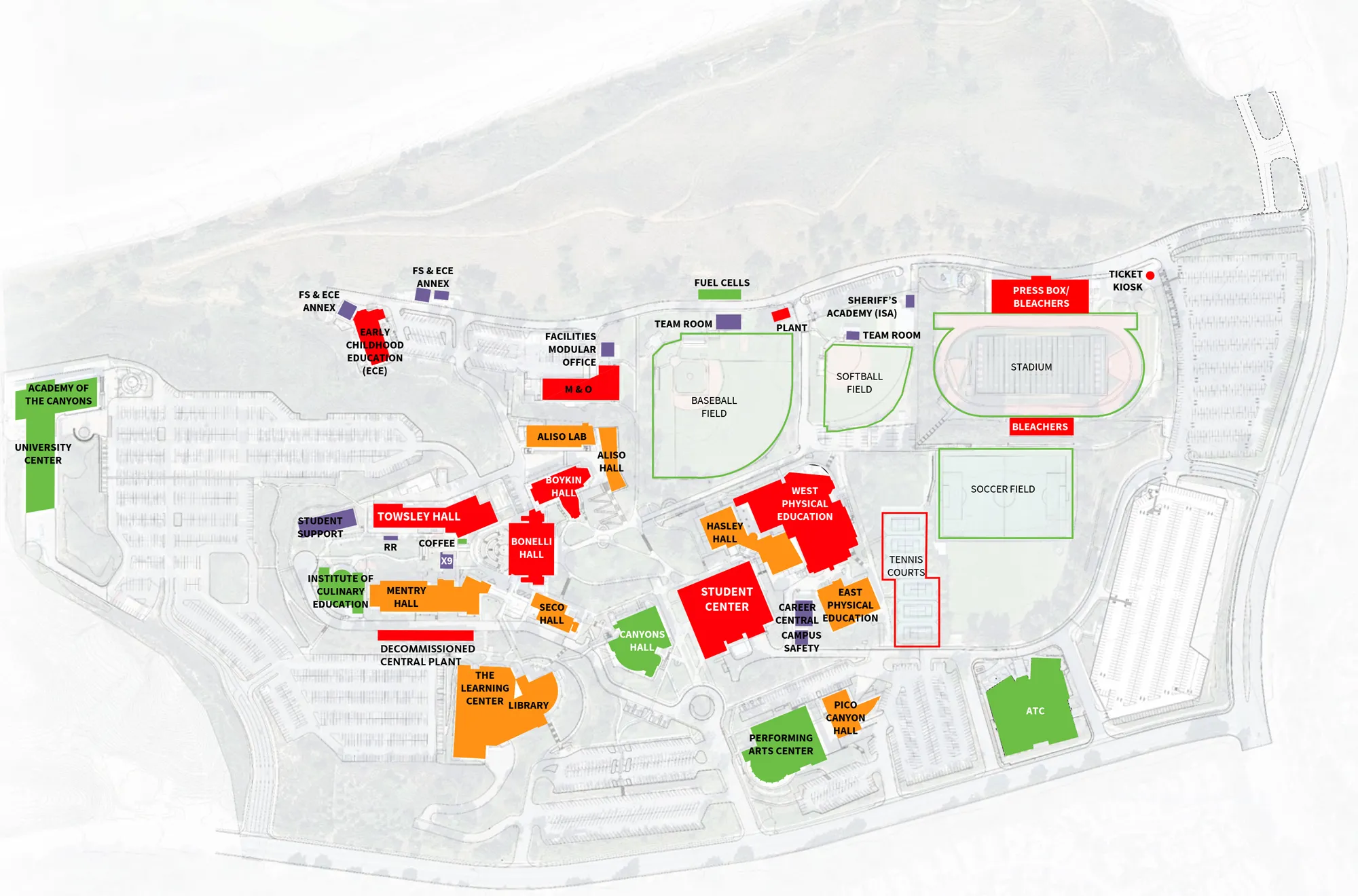
Color-coded Valencia campus map showing labeled buildings and athletic facilities, including a stadium, soccer and softball fields, baseball field, tennis courts, and student center.The Facility Condition Index (FCI) is a tool used to gauge the physical condition of a building. The California Community College Chancellor’s Office regularly surveys campuses to assess facility conditions and assign an FCI score. This score represents the ratio of the cost to renovate versus the cost to replace a building. Click map to enlarge.

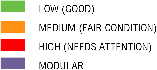
Color legend with green for Low (Good), orange for Medium (Fair Condition), red for High (Needs Attention), and purple for Modular. 


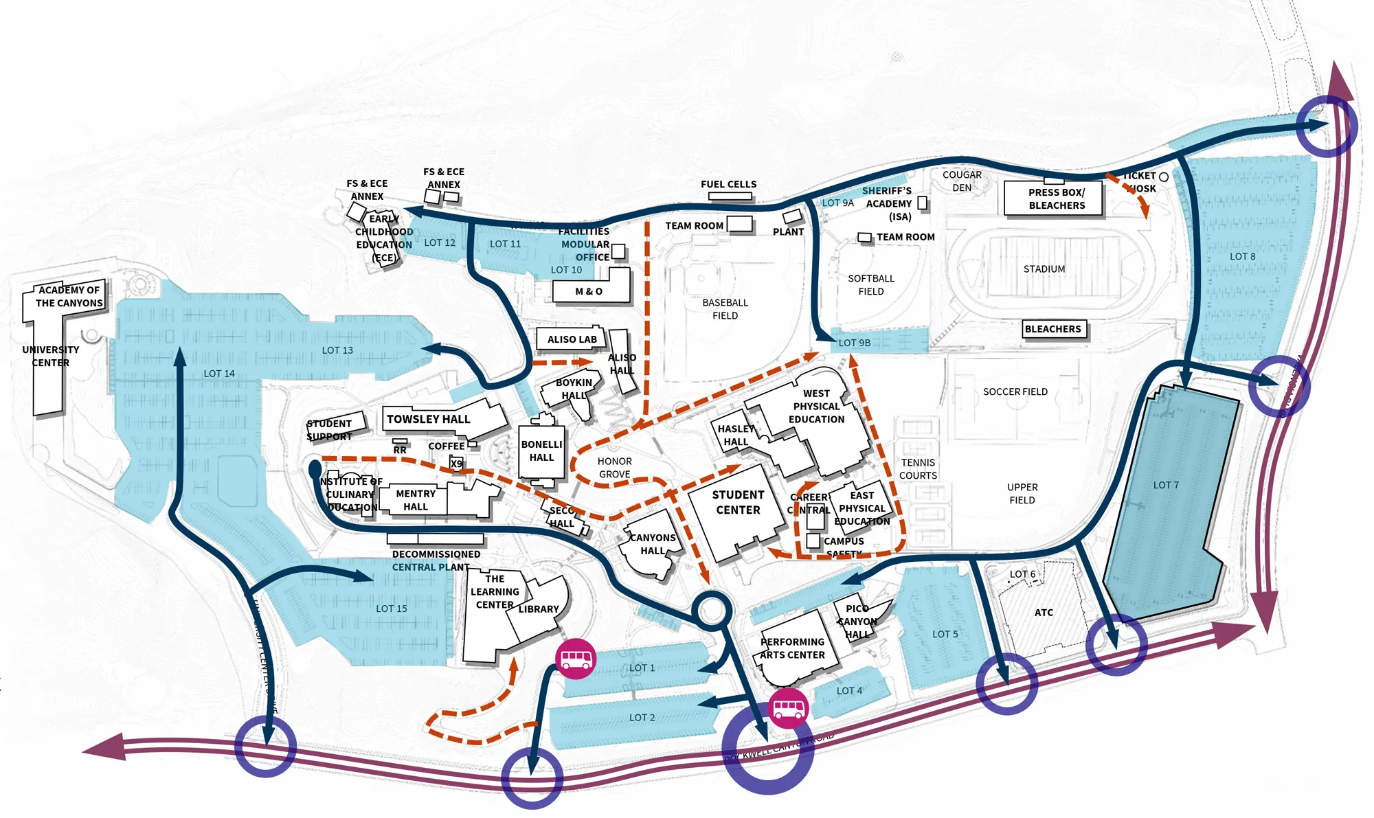
Valencia campus map showing buildings, athletic fields, and parking lots with highlighted routes and drop-off points, including the stadium, student center, library, and performing arts center.This diagram represents the existing vehicular experience on campus, with key observations as noted. Click map to enlarge.

  • Parking in Lot 14 is confusing and congested.
  • Multiple entries along the main road make the primary entry unclear.
  • High school pick-ups in Lot 14 and at the roundabout cause congestion.

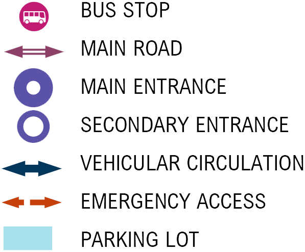
Map legend listing symbols for bus stop, main road, main entrance, secondary entrance, vehicular circulation, emergency access, and parking lot.


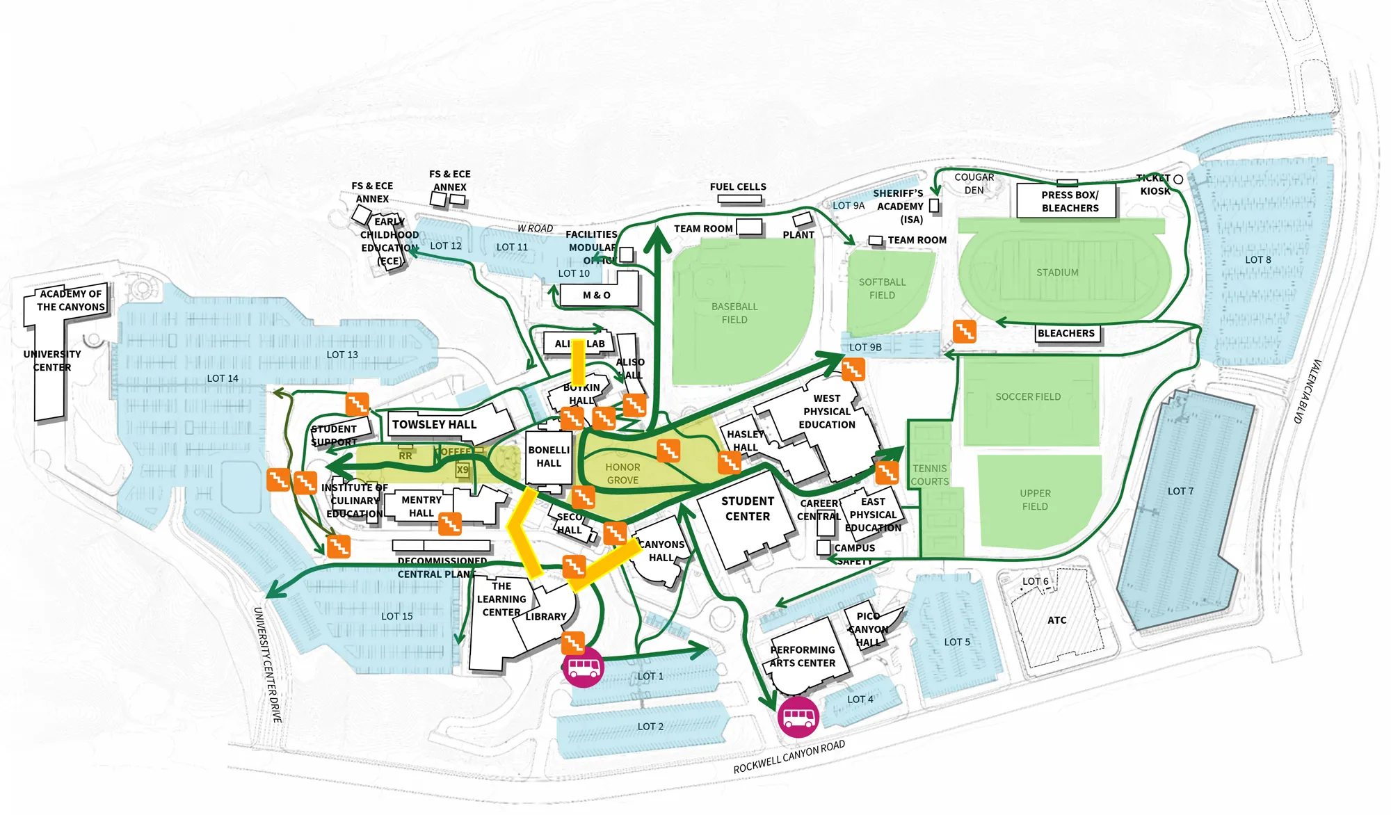
Valencia campus map showing buildings, parking lots, and athletic fields, with green routes and shuttle stop icons connecting key facilities.This diagram represents the existing pedestrian experience on campus, with key observations as noted. Click map to enlarge.

  • Vehicular-pedestrian conflicts exist in Lot 14 and at the campus entry.
  • Stairs and campus topography are difficult to navigate and limit access.
  • Wayfinding is challenging; lack of clarity in zoning of functions.

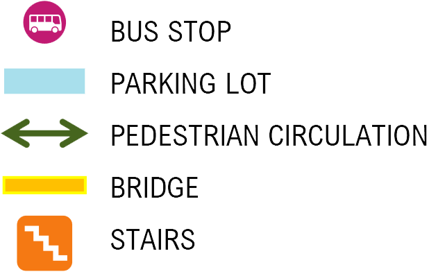
Map legend listing symbols for bus stop, main road, main entrance, secondary entrance, vehicular circulation, emergency access, and parking lot.


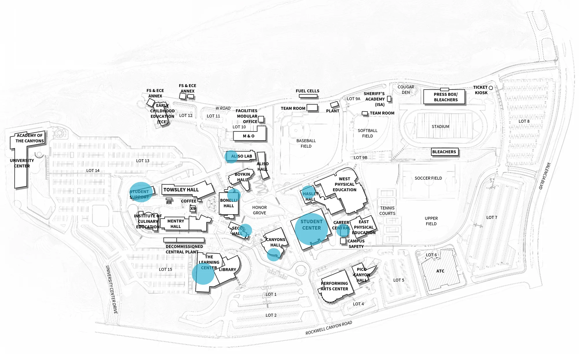
Valencia campus map showing building locations, parking lots, and athletic facilities, with several key buildings highlighted in blue (e.g., Student Center, Library, and Towley Hall).This diagram represents the location of existing student support programs and services located across campus, with key observations as noted. Click map to enlarge.

  • Student support services are spread out across campus.
  • Students have difficulty finding the services they need.
  • Some support services are located in a modular building far from other services.

Blue dot next to explanatory text stating that dot size relative to a building footprint shows the scale of programs and services offered at each location.


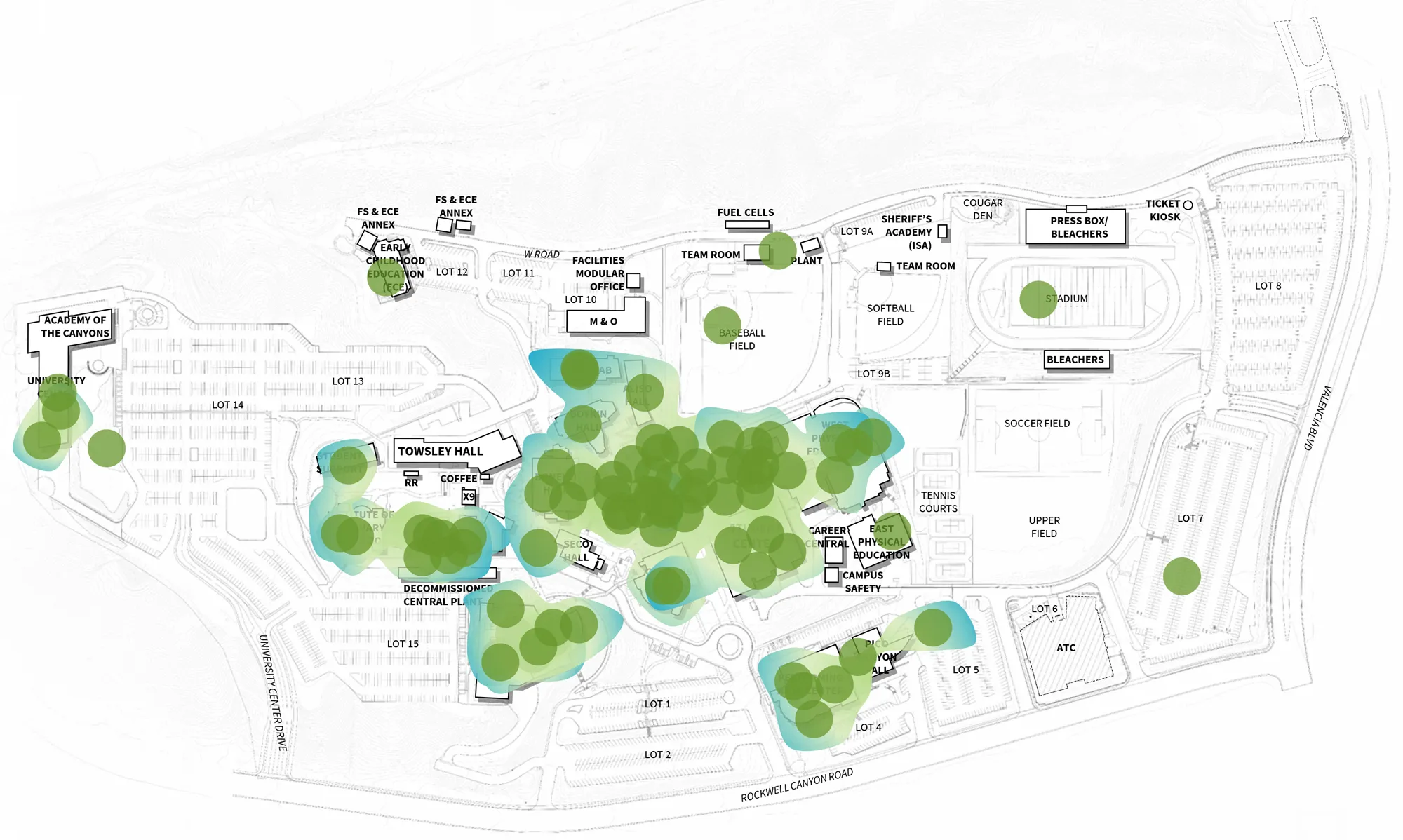
Valencia campus map with labeled buildings and athletic fields overlaid with green dots and blue highlights indicating areas of activity or concentration.During the Opening Day and CougarFest forums during the fall 2025 semester, students and employees were asked to identify their favorite places on campus. The results are highlighted on this graphic with key observations as noted. Click map to enlarge.

  • The Honor Grove is a popular place for people to engage, relax, and recharge.
  • Students love the shows and events at the Art Gallery.
  • The Student Center is a well-loved place to obtain resources and support services.

Green circular icon next to the text "Favorite Place".


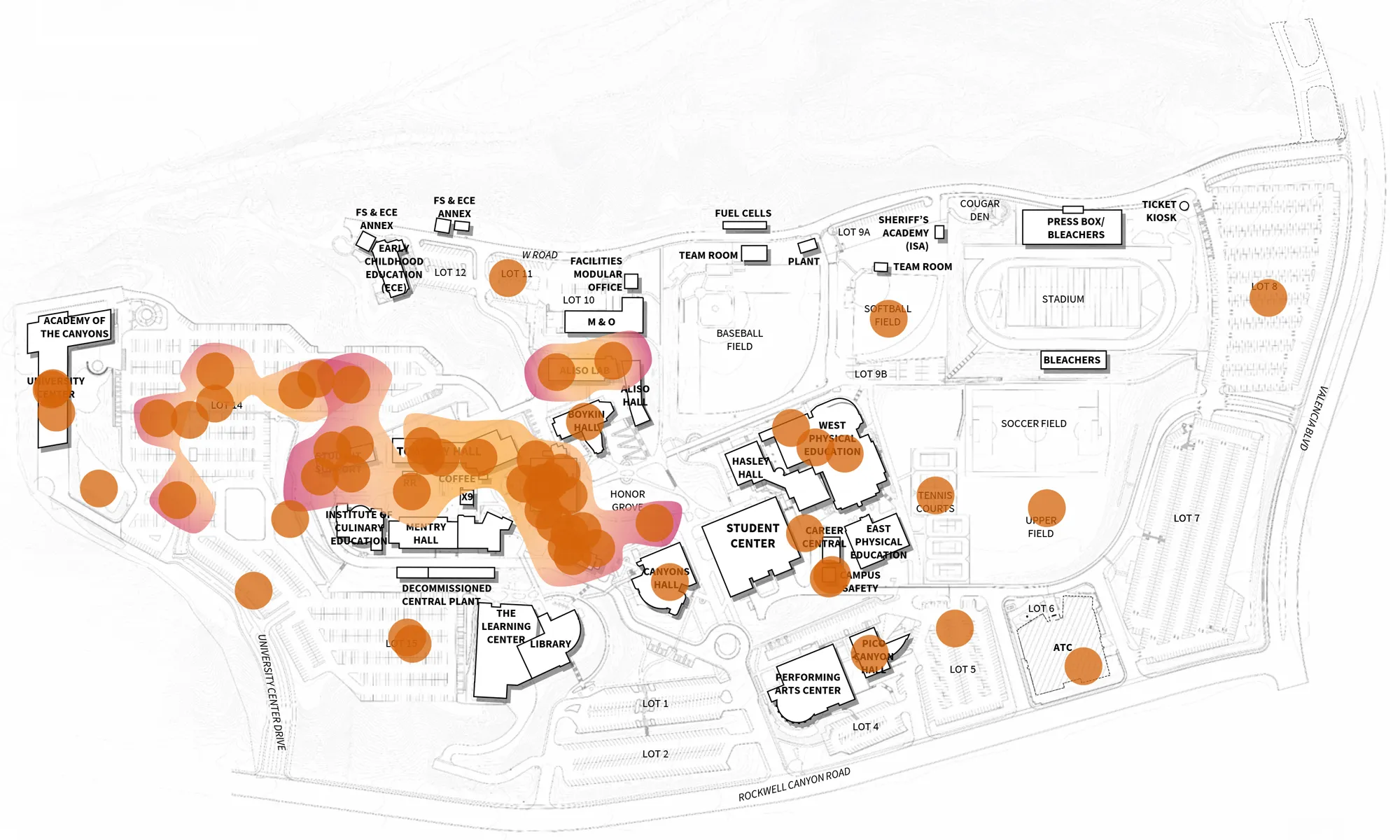
Valencia campus map with numerous orange and red translucent circles marking locations across buildings, parking lots, and athletic fields.During the Opening Day and CougarFest forums, students and employees were asked to identify their least favorite places on campus. The results are highlighted on this graphic with key observations as noted. Click map to enlarge.

  • Old, outdated, and under-maintained facilities were identified as least favorite places.
  • Students commonly noted that some parking feels inconvenient.
  • Students and employees noted steep stairs make the campus topography difficult to navigate.

Orange circular icon next to the label “Least Favorite Place.”


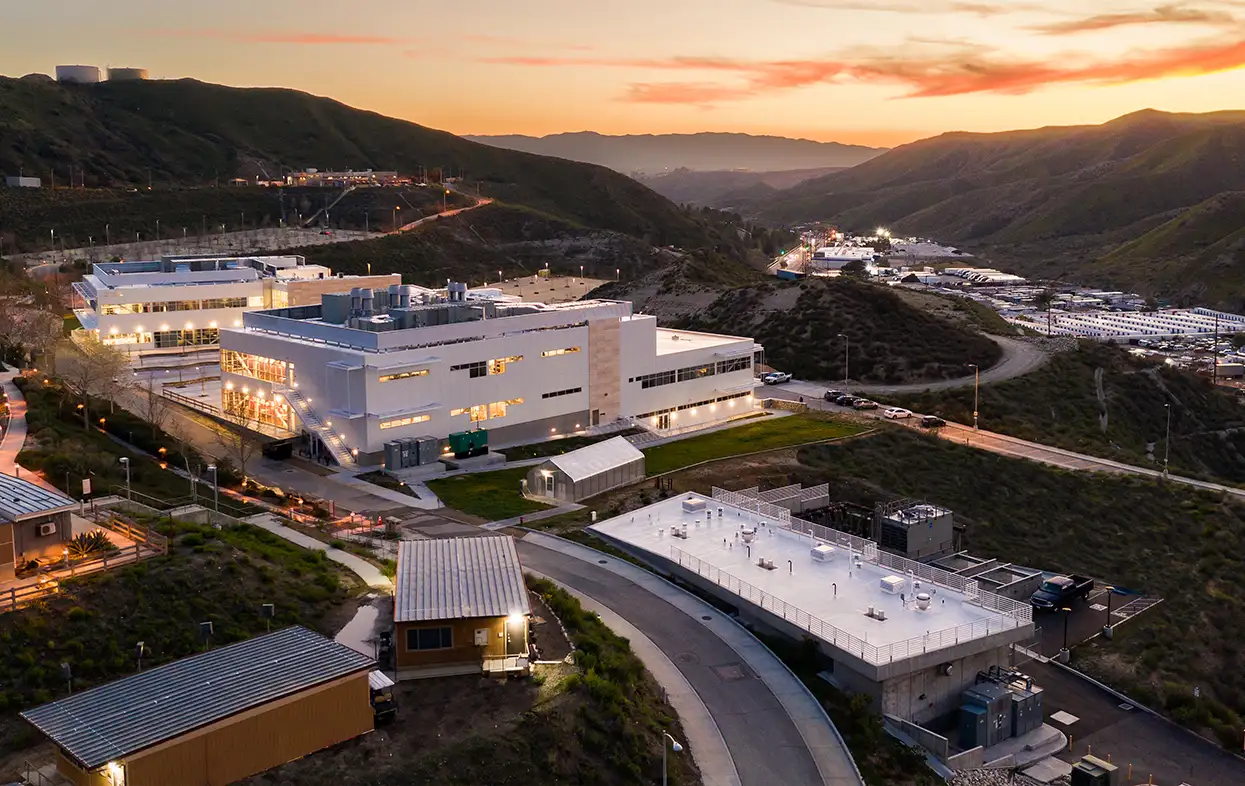
Aerial view at dusk of the Canyon Country campus.

CANYON COUNTRY

EXISTING CAMPUS

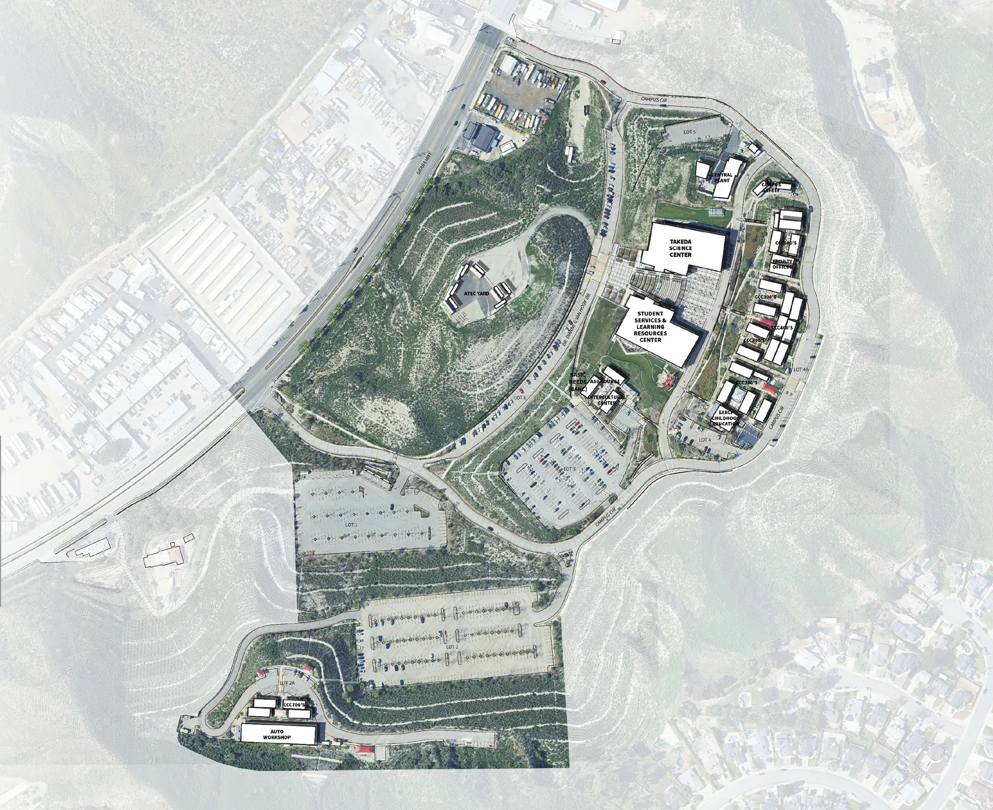
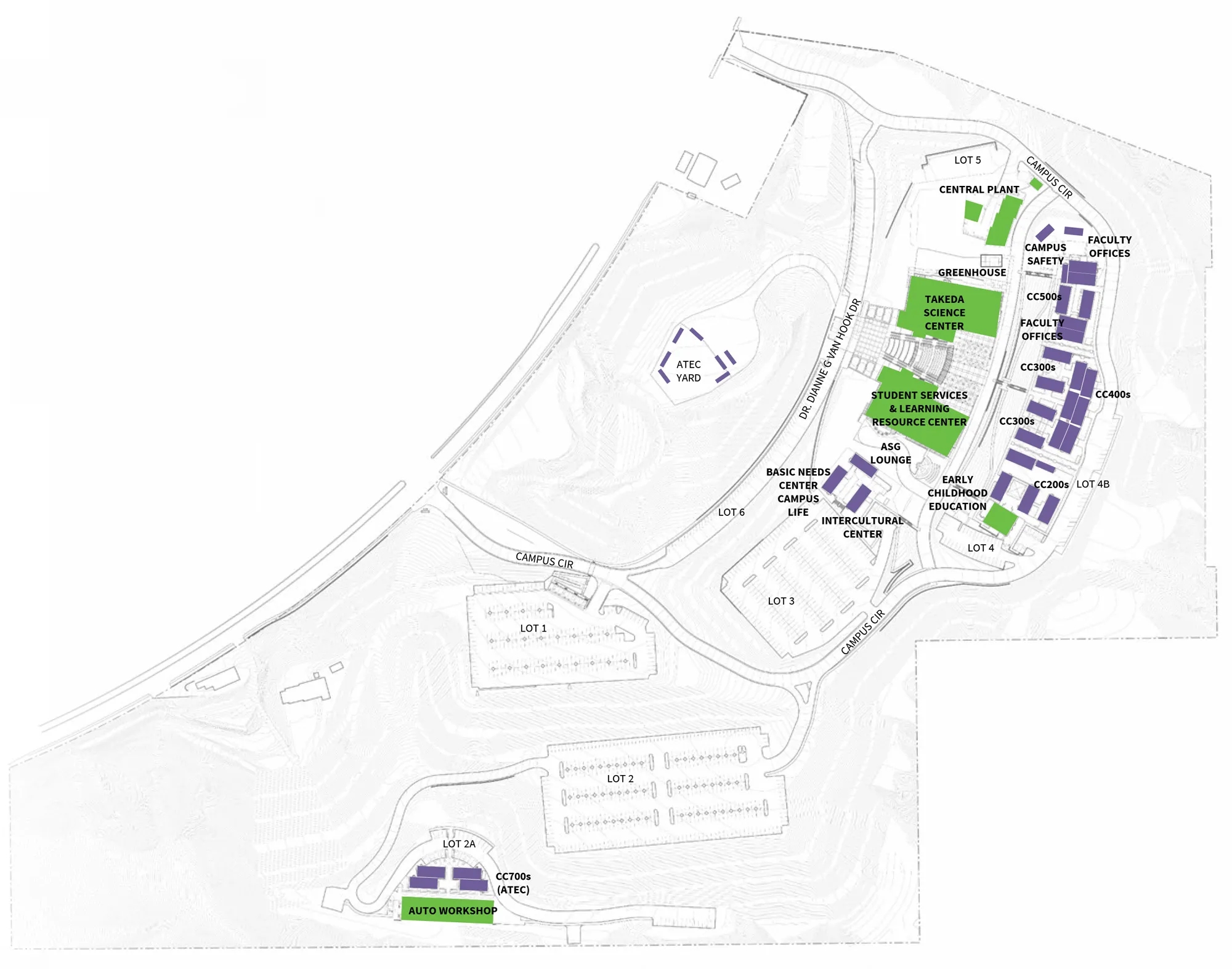
The Canyon Country campus is the college’s second campus, opened in 2007 on a 70-acre hillside high-desert property located along the south side of Sierra Highway. Most of the campus buildings were developed in the 2000s during its opening decade. The college opened the Don Takeda Science Center, a 55,000-square-foot science and laboratory facility, in 2021, which was followed shortly thereafter by the similarly designed Student Services and Learning Resources Center. This graphic represents the existing baseline conditions of the campus for the development of this plan. Click map to enlarge.

Annotated aerial site plan of the Canyon Country campus with roads, parking lots, landscaped open space, and labeled buildings including a student services center and student learning resources center.

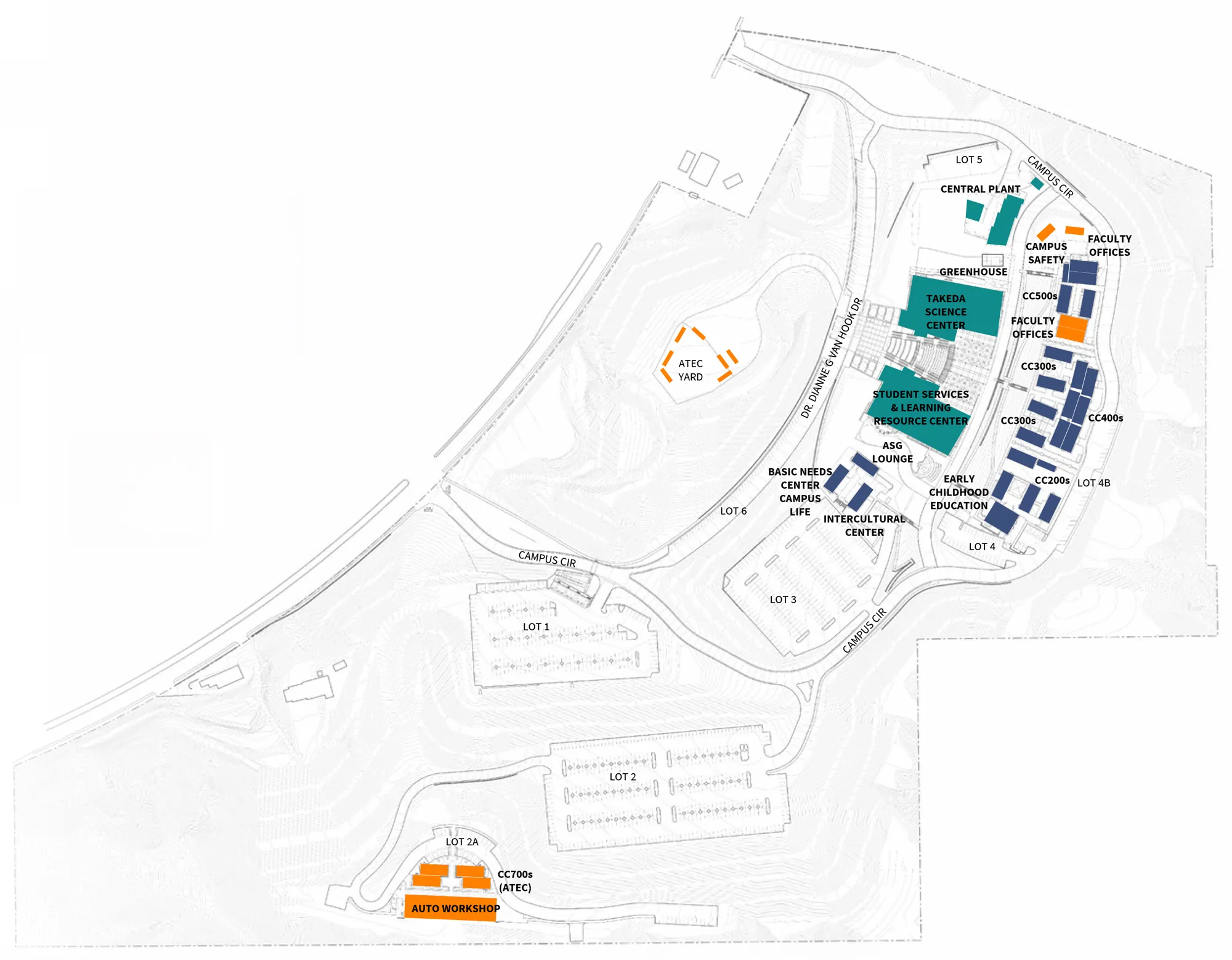
Color-coded Canyon Country campus map showing building clusters and key facilities, including the Takeda Science Center, Student Services & Learning Resource Center, Central Plant, greenhouse, and faculty offices, s

This map graphic illustrates the development of the campus with buildings color-coded to indicate the decade of original construction. Most of Canyon Country Campus buildings were built in the 2000s during its opening decade. The college then opened the Don Takeda Science Center, a 55,000-square-foot science and laboratory facility in 2021. Click map to enlarge.

  • Most of the buildings on campus are modular buildings built in the 2000s.

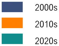
Legend showing three colored swatches (blue, orange, teal) labeled 2000s, 2010s, and 2020s.


Canyon Country campus site map showing roads, parking lots, and labeled facilities, with academic buildings in purple and student services and science/greenhouse areas in green.

The Facility Condition Index (FCI) is a tool used to gauge the physical condition of a building, regularly surveyed by the California Community Colleges Chancellor’s Office to assess conditions and assign an FCI score. This score represents the ratio of the cost to renovate versus the cost to replace a building. Click map to enlarge.

  • While the permanent buildings on campus are in good condition, most of the instructional space on campus takes place in modulars.

Two colored rectangles (green above purple) beside a legend labeling them as "Low (Good)" and "Modular.". 


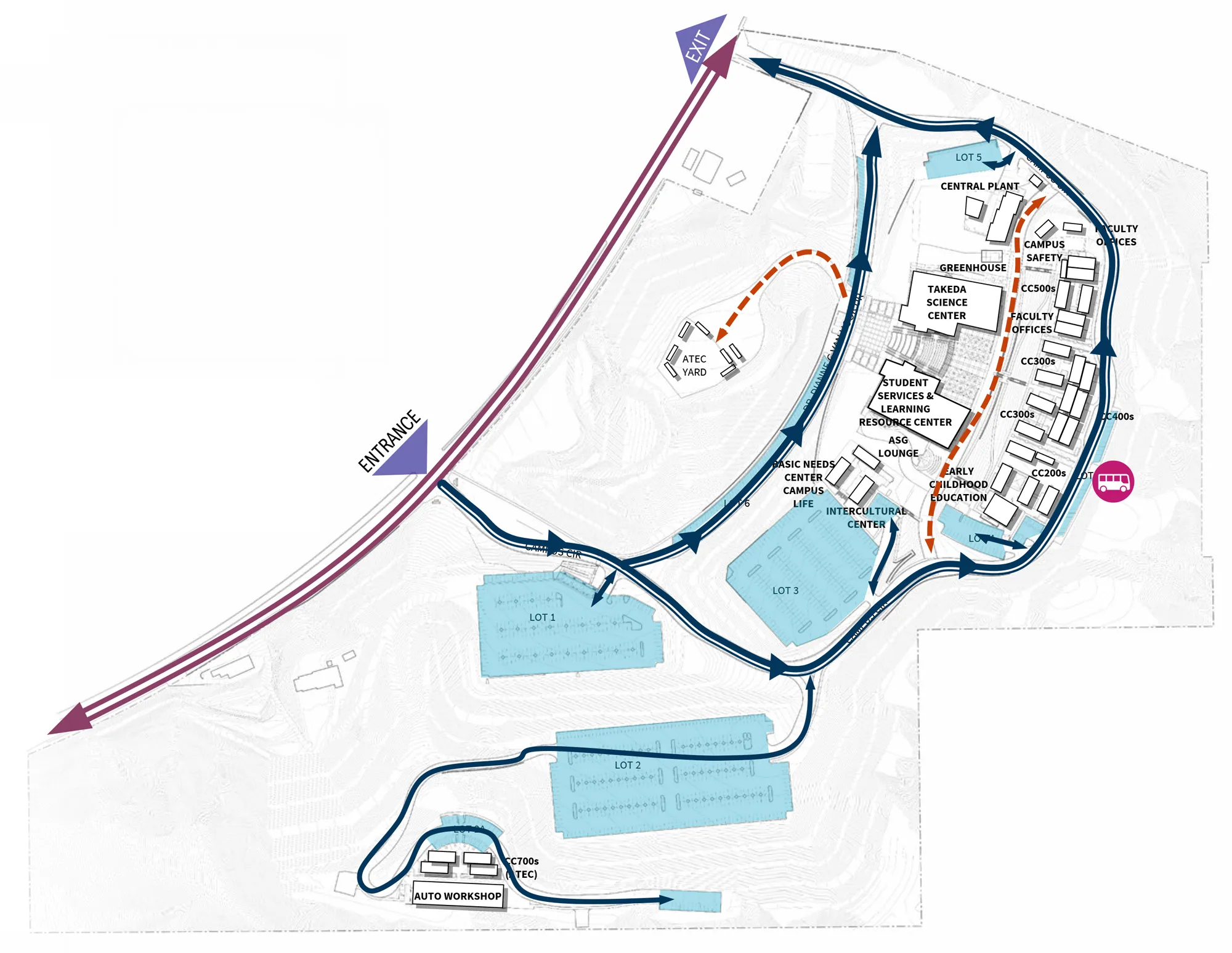
Canyon Country campus map showing a one-way traffic loop from the entrance past parking lots to key buildings, with arrows indicating directions and a marked bus stop on the east side.

This diagram represents the existing vehicular experience on campus, with key observations as noted. Click map to enlarge.

  • One-way traffic and singular entry/exit points make navigation difficult.
  • Parking is limited and far away from classrooms.
  • The Auto Workshop and ATEC buildings are located up a steep hill with limited access to parking.

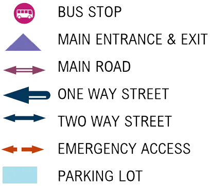
Legend of map symbols showing icons for bus stop, main entrance and exit, main road, one-way street, two-way street, emergency access, and parking lot.


Canyon Country campus site map showing buildings, parking lots, and shuttle/bus stops, with green arrows indicating routes between major facilities and lots.

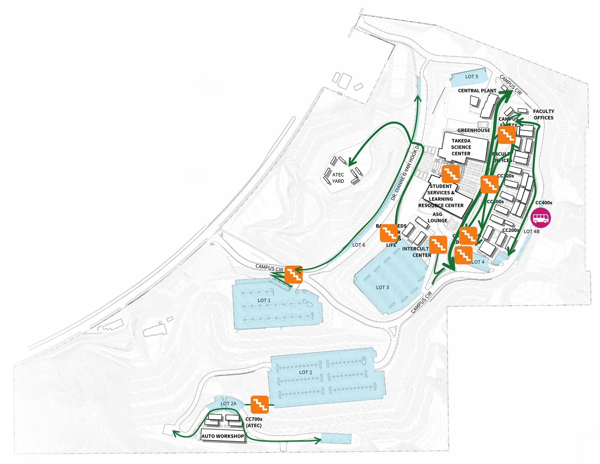
This diagram represents the existing pedestrian experience on campus, with key observations as noted. Click map to enlarge.

  • Stairs are steep and difficult to navigate.
  • The Auto Workshop, CC700s (ATEC classrooms), and ATEC Yard are too far from student resources and have limited parking.
  • Although pedestrian access to the ATEC Yard is discouraged, pedestrian access still occurs
  • The lack of trees and shade make outdoor spaces difficult to occupy.
  • Dumpsters near campus safety are an eyesore.

Map legend showing icons and labels for bus stop, parking lot, pedestrian circulation, bridge, and stairs.


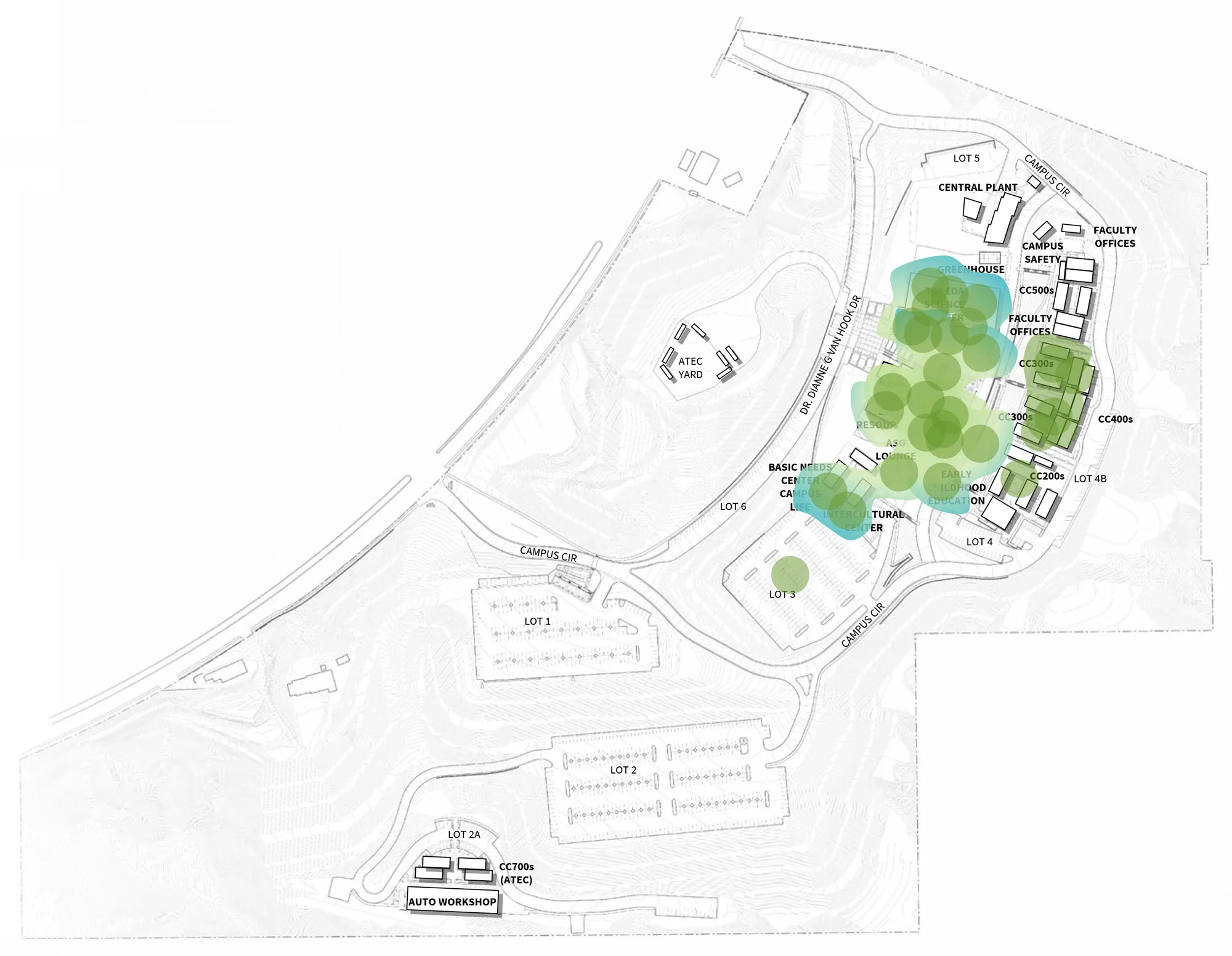
Canyon Country campus site plan showing buildings, roads, and parking lots, with green and blue circles highlighting a cluster of trees near the central campus buildings.

During the Opening Day and CougarFest forums, students and employees were asked to identify their favorite places on campus. The results are highlighted on this graphic with key observations noted on this page. Click map to enlarge.

  • Students and employees like the Science Center for its new facilities and as a one-stop shop for students.
  • Study spaces with air conditioning are popular amongst students.
  • The ASG Lounge, Basic Needs Center (BaNC) and Campus Life are well-used resources by students.

Green circular icon next to the text "Favorite Place".


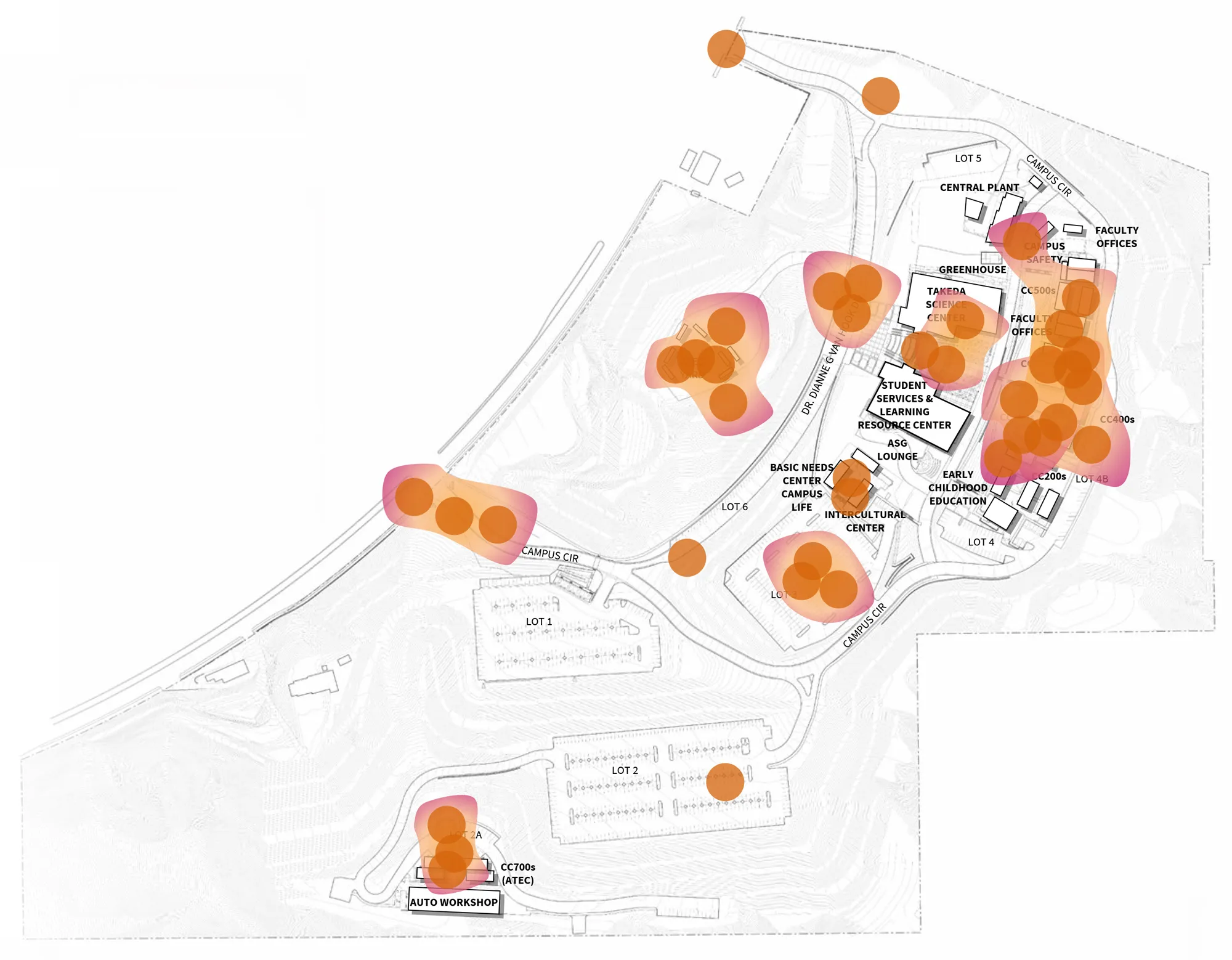
Canyon Country campus site map with a heatmap overlay of orange and pink circles indicating clustered activity hotspots around multiple buildings and parking lots.

During the Opening Day and CougarFest forums, students and employees were asked to identify their favorite places on campus. The results are highlighted on this graphic with key observations noted on this page. Click map to enlarge.

  • Students and employees noted the Auto Workshop and ATEC as difficult to access and navigate.
  • Poorly designed one-way traffic and speed bumps were noted by both students and employees.
  • Portable classroom buildings were mentioned as needing improvement.

Orange circular icon next to the label “Least Favorite Place.”


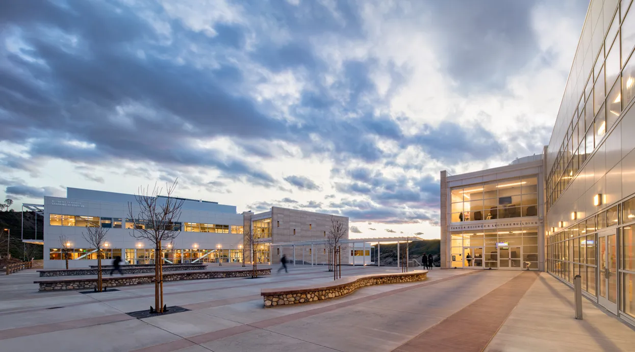
View of the Takeda Science Center (right) and the Student Services & Learning Resources Center (left) at the Canyon Country campus.
| Planning Framework

OVERVIEW

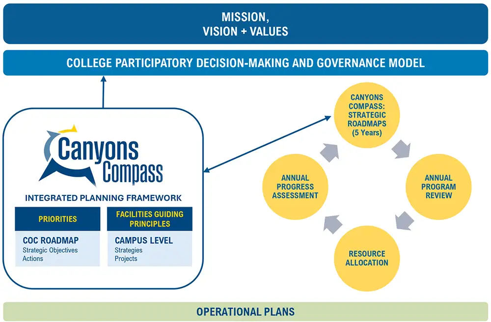
The Canyons Compass planning framework aligns the college’s core beliefs, aspirations, and commitments with clear strategic direction. The college’s values, vision, and mission serve as the foundation for setting priorities and goals that inform planning across colleges, services, and facilities.

This structure ensures coherence and connection and comes to life through actionable goals, aligned tactics, and campus-level strategies that reflect shared purpose.

Collectively, this framework reflects a shared commitment to an inclusive, equitable, and student-centered college focused on access, outcomes, community, and growth.

Diagram of a college participatory decision-making and governance model linking mission, vision, and values to the Canyons Compass integrated planning framework, strategic roadmaps, annual assessment,


The Canyons Compass Integrated Planning Framework includes four collegewide strategic priorities and five facilities guiding principles. Collectively, this framework reflects a shared commitment to inclusive excellence.

  • The priorities provide the foundation for collegewide strategic objectives and action items.
  • The facilities guiding principles serve as the basis for campus development recommendations.

STRATEGIC PRIORITIES

Four blue tiles labeled: Academic Achievement; Institutional Health + Culture; Community Partnerships + Engagement; and Stewardship, Sustainability + Resilience.

FACILITIES GUIDING PRINCIPLES

Four blue tiles labeled: Academic Achievement; Institutional Health + Culture; Community Partnerships + Engagement; and Stewardship, Sustainability + Resilience.

View of the Takeda Science Center (right) and the Student Services & Learning Resources Center (left) at the Canyon Country campus.

| Future Vision

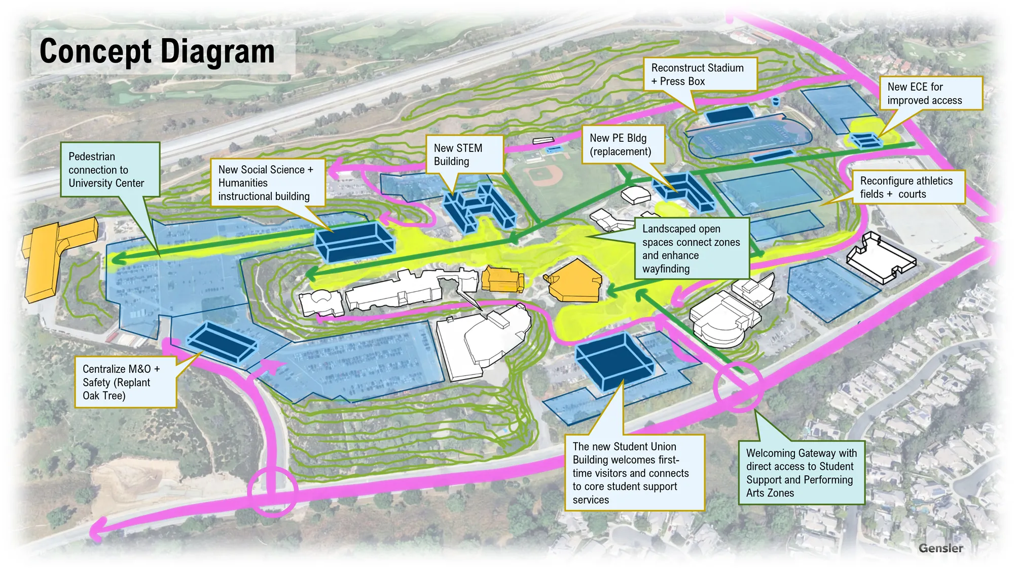
VALENCIA CAMPUSConcept diagram map of the Valencia campus showing proposed new buildings, pedestrian routes, landscaped open spaces, and reconfigured athletics facilities with labeled callouts.
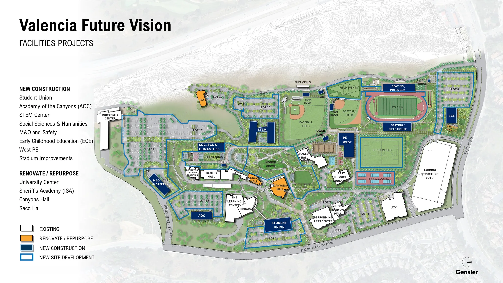
Campus facilities projects site plan showing existing buildings and proposed new construction and renovations, including academic buildings, student union, parking, and athletic fields and stadium.
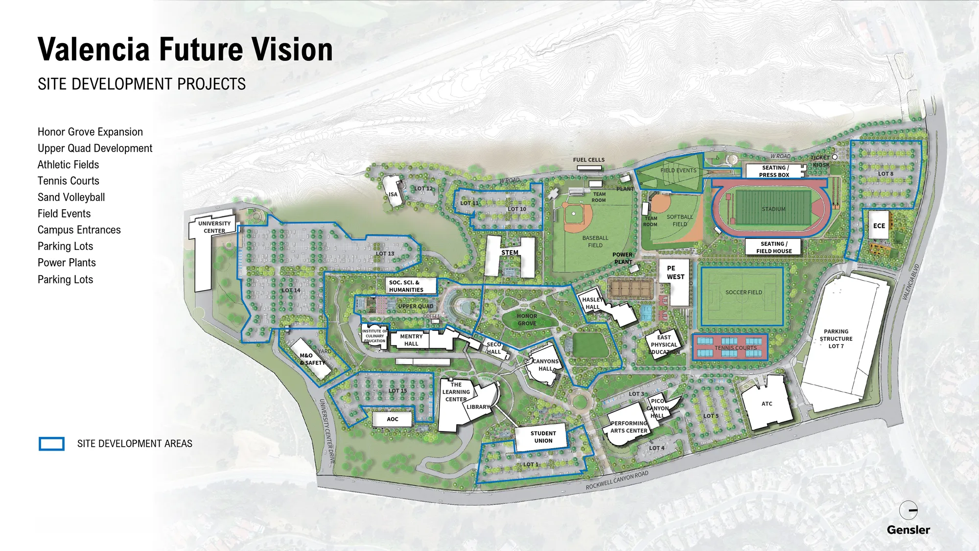
Campus site plan labeled "Site Development Projects" with buildings, parking lots, athletic facilities, and entrances, highlighting site development areas in blue outlines.
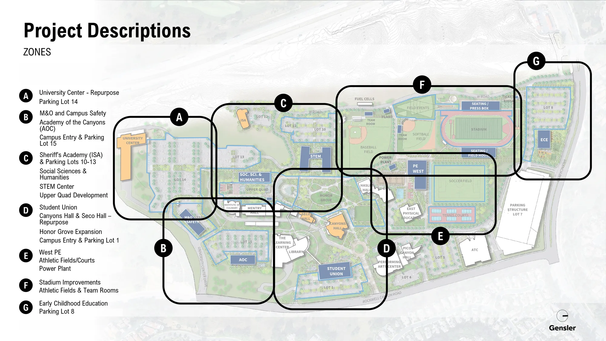
Campus map labeled “Project Descriptions” with seven outlined zones (A–G) highlighting areas for upgrades such as parking, academic buildings, student union, athletics, stadium, and early childhood教育.
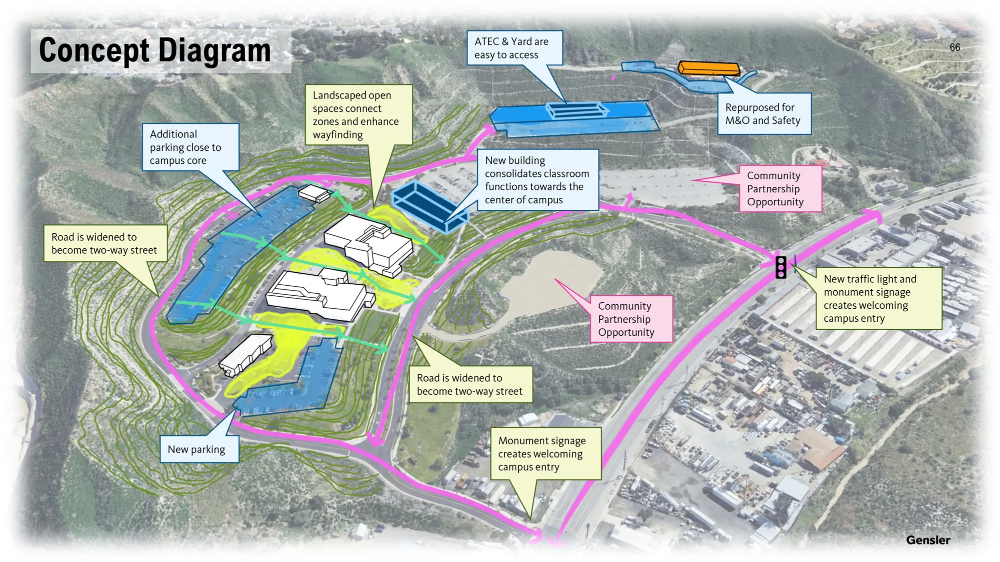
CANYON COUNTRY CAMPUSConcept diagram over an aerial site map showing a campus plan with new buildings, added parking, landscaped open-space connections, road widening to two-way streets, and improved entry features like a
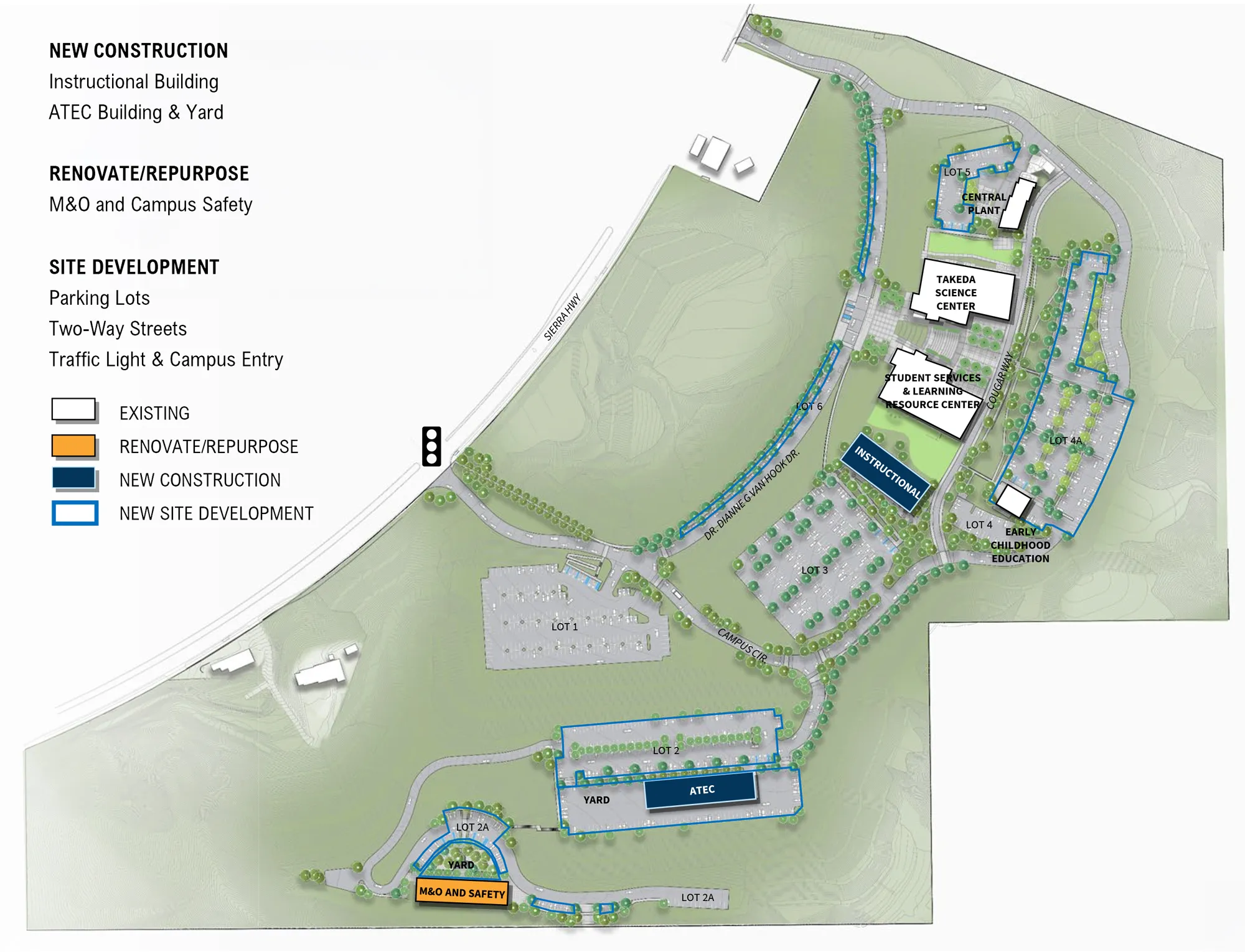
Campus site plan showing existing buildings and proposed projects, including new instructional and ATEC buildings, renovations for M&O and campus safety, and site development for parking lots, two-way
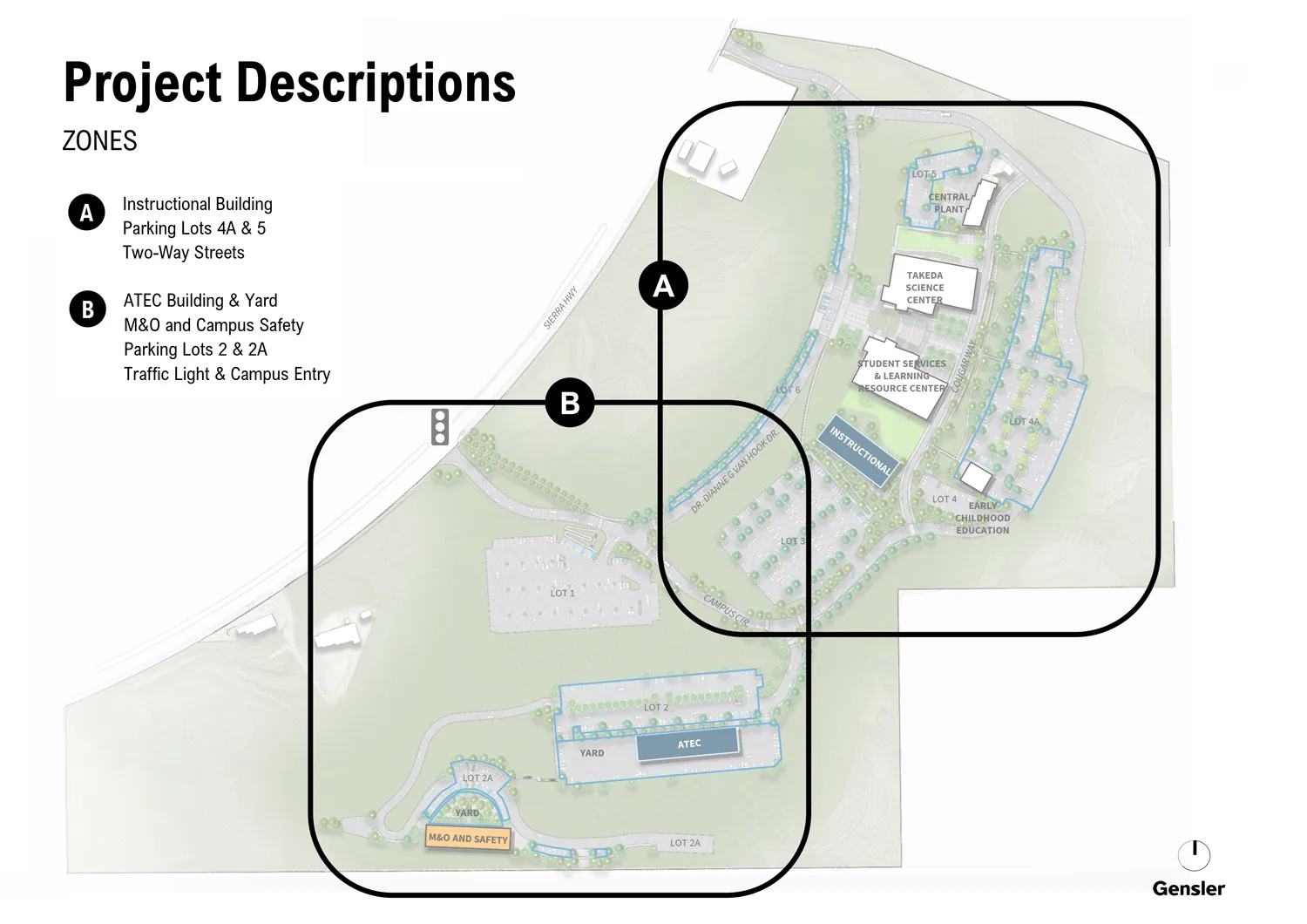
Site plan titled “Project Descriptions” highlighting two zones (A and B) with outlined areas showing campus buildings, parking lots, streets, and a traffic light/entry location.

Looking Ahead

In 2026-27, the Canyons Compass plan moves from establishment into active build-out, with three priorities advancing in parallel:

Develop 5-Year Roadmap

Translate the Canyons Compass strategic priorities into a sequenced, multi-year plan with defined strategies, milestones, responsible persons, and resource implications. Importantly, the Roadmap serves as the connective layer across the district's core planning processes, aligning Program Review, Enrollment Management, and Student Equity & Achievement plans, among others, so that unit-level priorities, enrollment strategies, and equity goals advance a shared direction rather than operating in parallel.

Complete Design Guidelines

Finalize and adopt comprehensive design standards governing the district's physical and visual environment, including architecture, furnishings, signage, wayfinding, landscaping, exterior and interior design elements, and campus aesthetics. These standards will serve as an implementation tool for Canyons Compass, ensuring future campus improvements and investments reflect a cohesive identity and support the district's long-term vision while creating a welcoming and consistent experience across all sites.

Refresh District Brand Identity

Update the district's visual identity to reflect the vision, values, and future direction established through Canyons Compass, including the development of a new logo. Coordinated with the Design Guidelines, the refreshed brand will strengthen institutional recognition, create consistency across campuses and communication platforms, and reinforce a unified sense of place for students, employees, and the community.


Graduating student in cap and gown raises their arms in celebration beside the Canyons Compass logo and the text “Charting the Next Decade of Success at College of the Canyons.”

More Detail

Learn more by viewing the full plan and supplemental information.

CANYONS COMPASS SUPPLEMENTAL INFO